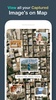

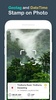
GPS Map Camera allows you to conveniently add GPS location details and timestamps to your photos, ensuring that you can always recall the exact location where each photo was taken. The purpose of this app is to geotag images by embedding details such as latitude, longitude, date, time, weather, and compass information directly onto your photos. This feature is especially beneficial for individuals and professionals who rely on precise location data for documentation or sharing purposes.
User-Friendly Geotagging Features
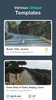
This app provides a seamless experience, displaying GPS coordinates and additional information on the camera preview while capturing your photos. You can customize the appearance of the geotags using various templates, providing an aesthetically pleasing addition to your images. After capturing your photo, saving or sharing it with others is just a single tap away, making the process straightforward for all users.
Broad Applications and Usage
GPS Map Camera proves to be a valuable tool for a wide range of uses. Travelers and explorers can document their journeys, while professionals in fields like real estate, architecture, and civil engineering can easily share location-stamped images with clients and colleagues. Additionally, event attendees, bloggers, and those in location-focused industries find it useful for enhancing their experiences or communicating information effectively.
Precise Location Stamping
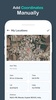
With GPS Map Camera, embedding location-specific details onto your photos becomes effortless. This geotagging solution not only enhances personal photo-taking experiences but also serves as an essential tool for businesses or individuals requiring accurate location documentation.
Requirements (Latest version)
- Android 6.0 or higher required
Comments
There are no opinions about GPS Map Camera yet. Be the first! Comment